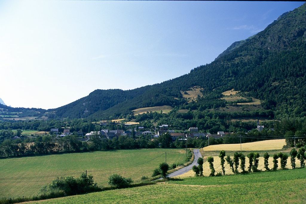
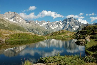
2. Stage 2: Le Noyer - Chaillol - Champoléon
This long stage on the south face of Champsaur begins with a descent as far as the River Drac and a steep climb to reach Beaurepaire and the Valgaudemar. It precedes a long ascent to the resort of Chaillol 1600. You then ride along a series of “Enduro”-style single tracks, taking you below the Palastre. After a final climb to Les Richards, there is a fine descent towards Champoléon to round off this stage.
Description
The hardest part of the trip! The start is along a nice descending track around the Faraut mountain, until you reach Lacoue and La Guinguette. After crossing the RN 85 road /!\ at Pont de la Guinguette, the serious business begins with a steep climb. The path heads towards Saint Eusèbe-en-Champsaur, after which you can recover by following the short Bocage path leading to Beaurepair. After a brief visit to the Valgaudemar (the route follows a short section of the GR 50), you cross towards Les Infournas via the picturesque villages of Motte-en-Champsaur and Charbillac (opt for the path rather than the D123). You then go up into the valley of Galaurie and pass in front of the Subeyrannes Forest House. Go through the Barbeyroux wood and then follow the Mal Cros canal. After an interesting and technical ascent, you arrive at the regional GR above Chaillol 1600. At Aiguilles de Famouroux, leave the GR for a steep track /!\ that joins up with a path you need to take on your left. In Le Vernet, don’t miss the fork, and take the left-hand track leading to Les Roranches. After the village, there is a meaty Enduro section /!\ leading to the source of the Doue and the Baumette cabin trail. One last ascent up to Les Richards and then you can enjoy the crossing and the descent (towards La Coche and the plateau of the same name) through the cool Champoléon valley as far as Les Borels.
- Departure : Le Noyer
- Arrival : Les Borels - Champoléon
- Towns crossed : Le Noyer, Chauffayer, Saint-Eusèbe-en-Champsaur, Les Costes, La Motte-en-Champsaur, Les Infournas, Bénévent-et-Charbillac, Saint-Bonnet-en-Champsaur, Saint-Julien-en-Champsaur, Saint-Michel-de-Chaillol, Saint-Jean-Saint-Nicolas, and Champoléon
19 points of interest
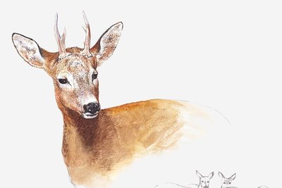
Chevreuil - Pierre-Emmanuel Dequest -PNE  Fauna
FaunaRoe deer
Walnut forests are a favourable home for roe deer. They came from Italy, the Isère and Drôme regions, and were added to some forty animals that were released between 1969 and 1975 in the neighbouring forests of Durbon and Morgon. This timid animal can be recognised by its red-brown coat and white patch on its rear.
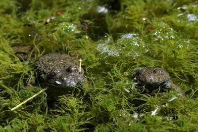
Sonneur à vendre jaune - Mireille Coulon - PNE FaunaYellow-bellied toad
Between the mountains and the River Drac, the water flows down as mountain streams and irrigation canals, hollowing out the sediment in the fluvial-glacier terraces where the mountain pastures have emerged. As the layers of eroded material of varying size and with impermeable clay layers are built up, sources are formed and feed small ponds. The yellow-bellied toad is a small toad that flourishes in habitats like these. The species is in decline all over its area of distribution due to the reduction in the number of such habitats. This is caused by draining, the creation of dams, levelling work and timber transport, among others. The population of this small amphibian is monitored by the National Park authorities.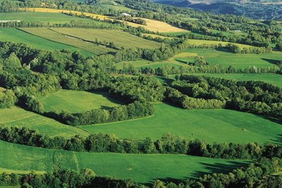
Bocage du Champsaur-Valgaudemar - Stéphane D'houwt - PNE  Flora
FloraThe Chamsaur woodlands
The woodland landscapes in lower Champsaur are unique in the Hautes-Alpes region. The network of hedges and canals surrounding the parcels of land result in agriculture of a high quality. Thanks to funding from the region and the EU in favour of maintaining the cultural and biological heritage, 70 species of trees and bushes, and over 80 bird species can be found here.
Le lac du Lauzon dans la vallée du Valgaudemar - Dominique Vincent - PNE  History
Valgaudemar
Tradition says the name of the valley comes from the Burgundian chief Gaudemar, who took refuge here in the 6th century. The local inhabitants lived for a long time from subsistence farming and mining. Mountain-climbing began to take off in the second half of the 19th century, and tourism in the 1960s. There are 30 peaks over 3,000 m. The highest point, Les Bancs (3,669 m), stands at the end of this long, narrow glacier valley.
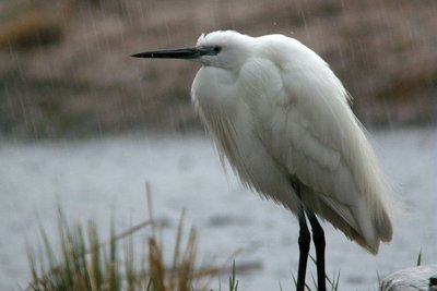
Aigrette garzette - Damien Combrisson - PNE FaunaOrnithologial diversity
Thirty years of careful inventories have identified 220 species of bird in the valley. This exceptional variety is not only due to the landscapes (hedges, wetlands, forests and high mountains) but also to the Champsaur's geographical position: not quite north-alpine, wide open to the south with the Manse and Bayard thresholds, ideal for exchange and for migratory birds such as herons, ducks, red-footed falcons or flycatchers.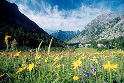
Prairie de fauche dans la vallée de Champoléon - PNE FloraHayfields
When they have not been disturbed by modern fertilisation techniques and silage, around fifty species of plant can still be found in the hayfields. The most symbolic are the poet's daffodil, alpine salsify, meadow sage, sainfoin and globeflower that punctuate the landscape with their different colours.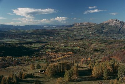
Le bocage du Champsaur, Saint-Michel-de-Chaillol - PNE FloraHedging
Hedged landscapes were quite common in France before the war, but here, above an altitude of 1000 m, a wonderful diversity has been maintained. A patchwork of hedgerows, prairies and woods are home to an array of birds. Amongst them are many common sparrows (red-backed shrikes, stonechats, sparrows, quails and wrynecks) whose numbers are in decline in France, sometimes alarmingly so. Richness is therefore not solely due to rarity.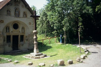
La chapelle des Pétêtes - Hervé Cortot - PNE HistoryPetetes Chapel
This chapel is an oddity as well as a remarkable piece of popular art. Here the "pepetes" are dolls! The story says that in 1730, a shepherd named Pascal, who also happened to be a mason, started chipping rocks. All winter he chipped away at the rocks. When he had chiselled enough, he dug the ground and placed the stones on top of each other. When he finished, the hamlet of Aubérie had a pretty, little mountain chapel. The mysterious shepherd had created small alcoves in the chapel's facade. He started chiselling again, but this time with greater precision and love, as he was sculpting statues. In 1741, after working 11 years, he finished his work of art and placed a monumental cross in front of the chapel.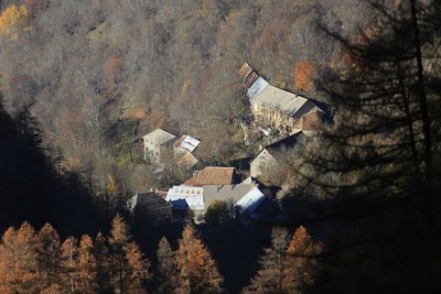
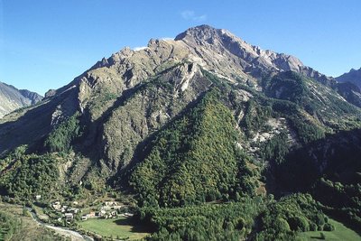
Les Infournas Hauts - Parc national des Écrins - Marc Corail  Geology and geography
Les Infournas
The locality is made up of two hamlets:
- Les Infournas-Bas, former administrative seat of the municipality, with the mayor's office and the church, standing at 1,245 metres above sea level.
- Les Infournas-Hauts, a starting point for mountain hiking, which stands at 1,373 metres above sea level.
It is only possible to access the Drac valley, a lifeline for the region, via two winding roads, one to the north-west towards Chauffayer 10 km away, the other to the south towards Saint-Bonnet-en-Champsaur which is 7 km away. Most of the territory is made up of the inhospitable and extensively ravined slopes of the mountains Le Cuchon and Le Queyron. To the south, woods constitute its only real resource.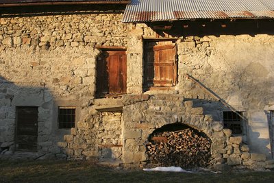
Une ferme aux Roranches, Champsaur - Marc Corail - PNE  Architecture
Champsaur architecture
Today's landscapes and the houses are no accident. They bear the trace of humans, who were less concerned with building attractive places, than with striving to find the best rigorously functional solutions for the area. In the northern part of the Drac valley, an area often faced with a cold wind, hedges were planted, buildings were close together and almost blind on the north-facing side. On the balconies to the east, as in St-Michel-de-Chaillol or St-Julien-en-Chapsaur, the aim was to find sunlight and the facade often had a large porch.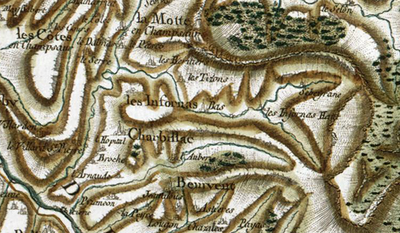
Carte de Cassini - IGN HistoryThe origin of the name "Champsaur"
A dozen origins explain the name "Champsaur". Obviously the prettiest one, and the least likely, is that it means "champ d'or" (Field of gold) as Napolean is said to have shouted out "what a beautiful field of gold" upon discovering the area. Other explanations are "field of lizards (sauros meaning lizard in greek) or "Sarrasins field" (campus sauracenorum) due to their numerous invasions. However, the most likely explanation is that it comes from "campus saurus" the field or the land of Saurus, the name of the owner at the time.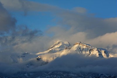
Le Vieux Chaillol, nuages et lumière du soir depuis Ancelle - Mireille Coulon - PNE Geology and geographyLe Vieux Chaillol
Easily visible from Champsaur and from beyond Gap, Le Vieux Chaillol is, like the Ecrins range, made up of granite rocks originating in the bedrock of the Cambrian era and which suddenly rose up some 5 million years ago. But the rocks of Le Vieux Chaillol have undergone a particular recrystallisation and have been transformed into metamorphic conglomerates and schists.
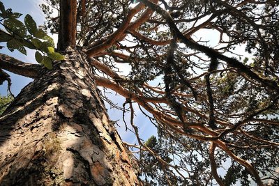
Vieux Pin sylvestre - Mireille Coulon - PNE FloraScots pine
The Scots pine can be recognised by its long reddish brown trunk and sparse foliage. The needles are grey-green, slightly curved and paired. It needs a great deal of sunshine, but can make do with poor, sandy soil that is unsuited to other trees. Its wood is light and of high quality.
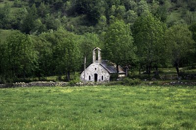
La Chapelle des Roranches - © Parc national des Écrins - Michel Francou  Vernacular heritage
Les Roranches Chapel
Built in 1780 on the site of a former chapel dedicated to Our Lady of the Assumption, the Roranches chapel is dedicated to Saint Pancras, the protector of farm animals and pets. It was built using humble architectural techniques, and is highly representative of the small places of worship in the Champsaur woodlands where, as so often in the mountains, the materials used were those that were ready to hand. Two renovation projects have been carried out on the chapel since 2013 with the support of the Ecrins National Park. The first was aimed at stabilising the barrel vault and renewing the framework and roof using the original material, slate. The second project was to restore the plasterwork inside and outside, as well as the whitewash, windows and flooring.
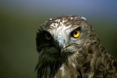
Circaète Jean-le-Blanc - Marc Corail - PNE FaunaShort-toed snake eagle
This bird of prey can be recognised because of its large head, its quite impressive wingspan (1.80m) and the white plumage under its wings and body. Despite its size, it rarely eat small mammals. Its food mainly consists of lizards and snakes. When it hunts, it takes up a particular position against the wind, poised in the air with its wings fully outstretched.
 Vernacular heritage
Les Richards
Perched up at an altitude of 1548 m above Pont-du-Fossé in the commune of Saint-Jean-Saint-Nicolas, the village of Les Richards is a haven of tranquillity. The view is breathtaking over the Autanes and the Champsaur woodlands. This is the starting point for a very popular hiking trail around the mountains or to the summit of the Palastre, and a take-off area for long-distance hang-gliders. It is not unusual for a hang-glider to land in Grenoble and sometimes even in Chamonix after a long day's flight from Les Richards! The record is 162 km, with a landing in Chamonix in 2002.
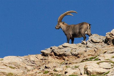
Bouquetin en été - Rodolphe Papet - PNE FaunaAlpine ibex
If you take a few minutes' walk at the end of the valley, you will be able to see some Alpine ibex. In September 1994, in Champoléon, some thirty animals from Vanoise area were released by Ecrins National Park rangers. This superb animal is heavier (100 kg) and less timid than the chamois, and is closely related to the domestic goat. It was almost extinct in the Alps. Today it is totally protected in France and is now safe extinction.
Le village des Borels - Marc Corail - PNE HistoryLes Borels
This is most important village in the Chamoléon district (no hamlet bears this name). Until towards the first world war in 1914, the valley lived in a closed circuit for all everyday items. At the Borels there was a weaver (wool and hemp), a miller-baker, an ironmonger, a mason, a breeches-maker and in the other hamlets, a cobbler, two millers, a joiner and two shoemakers. The latter worked from home.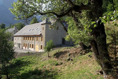
La Maison du Berger - Les Borels - Marc Corail - PNE Vernacular heritageThe Shepherd's House
Opened in memory of the shepherd and writer Pierre Mélet, the Maison du Berger ("the Shepherd's House") is a discovery and research centre focusing on Alpine pastoral cultures. It is a site of cultural outreach for all members of the public. There is an exhibition, educational activities for school groups, as well as a library for professionals and researchers, and a shop.
Altimetric profile
Sensitive areas
Golden eagle
- Impacted practices:
- Aerial, , Vertical
- Sensitivity periods:
- JanFebMarAprMayJunJulAug
- Contact:
- Parc National des Écrins
Julien Charron
julien.charron@ecrins-parcnational.fr
Peregrine falcon
- Impacted practices:
- Aerial, Vertical
- Sensitivity periods:
- FebMarAprMayJun
- Contact:
- Parc National des Écrins
Julien Charron
julien.charron@ecrins-parcnational.fr
Peregrine falcon
- Impacted practices:
- Aerial, Vertical
- Sensitivity periods:
- FebMarAprMayJun
- Contact:
- Parc National des Écrins
Julien Charron
julien.charron@ecrins-parcnational.fr
Short-toed snake eagle
- Impacted practices:
- Aerial,
- Sensitivity periods:
- MarAprMayJunJulAugSep
- Contact:
- Parc National des Écrins
Julien Charron
julien.charron@ecrins-parcnational.fr
Black grouse - winter
- Impacted practices:
- , Land
- Sensitivity periods:
- JanFebMarAprDec
- Contact:
- Fédération départementale des chasseurs des Hautes-Alpes :
Pierre-Frédéric Galvin : pierre-frederic.galvin@fdc05.com
Membre de l'Observatoire des Galliformes de montagne
Virginie Dos Santos : ogm.vds@gmail.com
Blandine Amblard : ogm.amblard@gmail.com
Source

Report a problem or an error
If you have found an error on this page or if you have noticed any problems during your hike, please report them to us here: