From L Danchère to Mizoen via Vénosc
Les Deux Alpes HardDifficulty
5. From L Danchère to Mizoen via Vénosc
8h30
Duration20,6km
Distance+1086m
Positive Elevation-888m
Negative ElevationStage
Course typeNetwork
Embed this item to access it offline
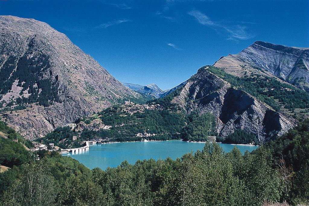
Explore the many villages and hamlets of the Oisans region following a variant of the GR®54. This Stage offers a route that alternates between traditional mountain occupations and contemporary amenities such as a ski resort and hydroelectric dam. After an undemanding path between La Danchère and Vénosc, the stage becomes more technically challenging, in pronounced mountainous surroundings.
Description
From the Danchère car park at Les Marmottes restaurant, turn right and follow the main tarmac road.
- Turn left at the next junction, walk down the road for a few dozen metres and then take a footpath that heads straight ahead at the bend in the road.
- After a few metres, take a wide path to the right, alongside the mighty Vénéon, and continue into the forest. At the ‘adventure park’, continue straight ahead until you reach a bridge on the left.
- Take this bridge and walk down to the hamlet of l'Alleau. Turn left at the bridge over the Vénéon and drive through Bourg d'Arud, staying on the main road towards Vénosc. Walk to the Tourist Office car park and turn right just after the building.
- Take the path that leads up alongside the cable cars. The path crosses the Ruisseau du Replat and ends up on the road at a crossroads.
- Take the road opposite, which climbs slightly (towards l'Eglise, Le Courtil). A few dozen metres further on, take the wide discovery path on the left leading to the Ferraret ruins (interpretation panels). Follow the signs for ‘Le Sapey’. The path then becomes narrower and rises, alternating between grassy areas and scree, gentle slopes and steep sections. On several occasions the path passes through rocky areas equipped with cables. The path crosses a number of gullies leading down from Pied Moutet. One of these gullies has been equipped with beams, cables and a ladder. The passage is exposed. Do not attempt it unless you have mountain legs. After this passage, a final climb equipped with cables takes you to point 1469: this is the end of the technical difficulties. The path then rises gently to the hamlet of Le Sapey.
- The GR then takes a small path to the ‘au Sarrête’ fork. Leave the track (follow signs for ‘La Molière’) for a path that climbs through the woods and crosses level with the Abiorots hut and spring.
- From here, the route descends to the hamlet of Les Molières. After a few hairpin bends, you reach a wide path that leads to Bons. From Bons you enter an urbanised area. The GR follows a street lined with villas, then joins the road to Mont de Lans (pedestrian path along the road).
- You cross Mont de Lans. After the roundabout, the path passes behind the guardrail and follows it before descending into the woods. Cross the road again and the path descends steeply to the Chambon dam.
- Cross the dam along the road and take the path that climbs steeply (it crosses the road twice) to Mizoen.
- Departure : La Danchère
- Arrival : Mizoen
- Towns crossed : Les Deux Alpes and Mizoën
Altimetric profile
Sensitive areas
Along your trek, you will go through sensitive areas related to the presence of a specific species or environment. In these areas, an appropriate behaviour allows to contribute to their preservation. For detailed information, specific forms are accessible for each area.
Golden eagle
- Impacted practices:
- Aerial, , Vertical
- Sensitivity periods:
- JanFebMarAprMayJunJulAug
- Contact:
- Parc National des Écrins
Julien Charron
julien.charron@ecrins-parcnational.fr
Golden eagle
- Impacted practices:
- Aerial, , Vertical
- Sensitivity periods:
- JanFebMarAprMayJunJulAug
- Contact:
- Parc National des Écrins
Julien Charron
julien.charron@ecrins-parcnational.fr
Peregrine falcon
- Impacted practices:
- Aerial, Vertical
- Sensitivity periods:
- FebMarAprMayJun
- Contact:
- Parc National des Écrins
Julien Charron
julien.charron@ecrins-parcnational.fr
Short-toed snake eagle
- Impacted practices:
- Aerial,
- Sensitivity periods:
- MarAprMayJunJulAugSep
- Contact:
- Parc National des Écrins
Julien Charron
julien.charron@ecrins-parcnational.fr
Short-toed snake eagle
- Impacted practices:
- Aerial,
- Sensitivity periods:
- MarAprMayJunJulAugSep
- Contact:
- Parc National des Écrins
Julien Charron
julien.charron@ecrins-parcnational.fr
Recommandations
Mountain experience necessary. Numerous handrails and ladders are installed, some in exposed locations.
Source

Parc national des Ecrinshttps://www.ecrins-parcnational.fr
Report a problem or an error
If you have found an error on this page or if you have noticed any problems during your hike, please report them to us here: