12. From the Refuge de la Muzelle to Mizoen
Description
- Follow the left-hand bank of the mountain stream La Muzelle until you reach a group of ruined houses called « le Cerisier », continue straight on across a long section of mountain pastures until, after a few twists and turns, the path runs into a forest. The path leads downhill to join a paved path. It crosses a small bridge and leads to the hamlet of L'Alleau.
- Continue straight on until you cross another bridge, over the Vénéon, and come to Le Bourg d'Arud. Head towards Vénosc (1,000 m). Walk to the Tourist Office car park and turn right immediately after the building.
- Take the path that runs up alongside the cable cars. The path crosses over the stream Le Replat and ends at a crossroads on the road.
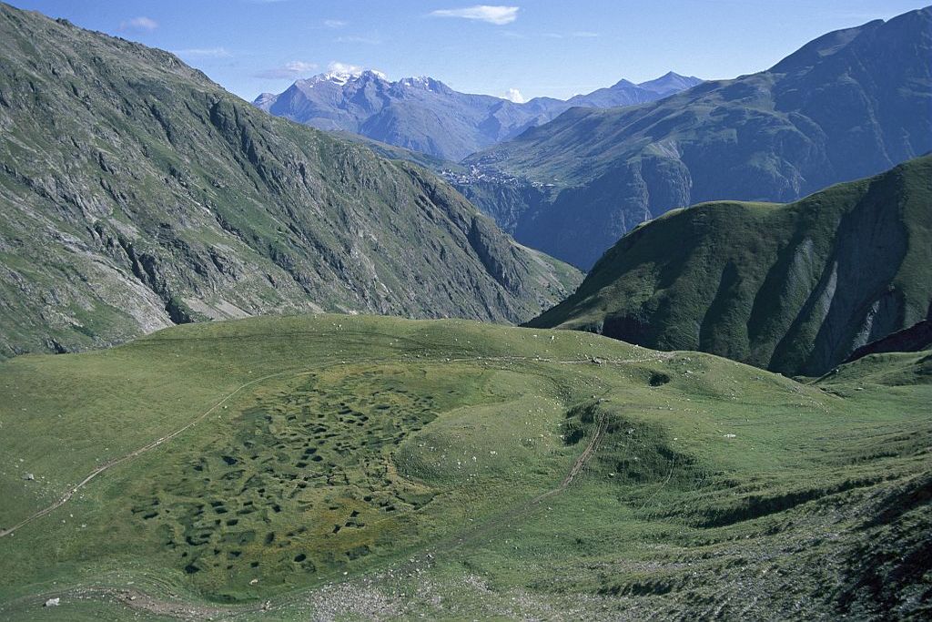
- Take the road straight ahead which rises gently (heading towards the church, Le Courtil). A few dozen metres further on, take the wide discovery path ("sentier de découverte") on the left which leads to the ruins of Le Ferraret (interpretation boards). Follow signs for "Le Sapey". The path narrows and starts to rise, alternating between grassy areas and screes, gentle slopes and steep sections. At several points, the path passes through rocky areas provided with cables. The path crosses several ravines which lead down from the Pied Moutet. One of these ravines has been provided with beams, cables and a ladder. LIt is an exposed crossing. Only attempt it if you have mountain experience. After crossing this ravine, a final ascent assisted by cables leads you to Point 1469: this is the end of the technically difficult sections. The path then ascends gently up to the hamlet of Le Sapey.
- The GR route then leads along a small track up to the « au Sarrête » fork. You then leave the track (heading towards "La Molière") joining a path that runs up through the wood and along a level section up to the cabin and the Les Abiorots spring.
- From there, the route drops down to the hamlet of Les Molières. After a few twists and turns, you join a wide path that leads to Bons. From Bons, you are entering an urbanised sector. The GR route follows a road edged with villas and then joins the Mont de Lans road (there is a pedestrian track on the side of the road).
- You pass through Mont de Lans. After the roundabout, the path runs behind the safety barrier which it follows before dropping down into the woods. You cross the road again and then the path drops rapidly down to the Chambon dam.
- Cross the dam along the side of the road and take the path that rises steeply uphill (it intersects the road twice) until you reach Mizoen.
- Departure : Refuge de la Muzelle, Vénosc
- Arrival : Mizoen
- Towns crossed : Les Deux Alpes and Mizoën
5 points of interest
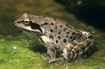
La grenouille rousse - PNE - Coulon Mireille  Flora
FloraFauna and Flora in the Bog
The bog is a very special environment which, by definition produces peat. Its appearance is that of a carpet of spongy sphagnum, plants full of water similar to mosses that accumulate over time. Their scientific study has enabled us to trace the evolution of the climate as well as that of the vegetation. The bogs can be seen at a distance when the Cotton Grass is in flower. Etymologically its name in French describes the 'portelaine' (wool carrier): its fluffy tufts and its cottony appearance make it an easily identifiable plant... You can also see around here and animal that is very active in this area: the common frog. Resistant to the cold, it is a batrachian which is very well adapted to the alpine environment. The yellow abdomen and the large dark mark at the back of the eye incorporating the ear drum are two characteristics observable with this species...
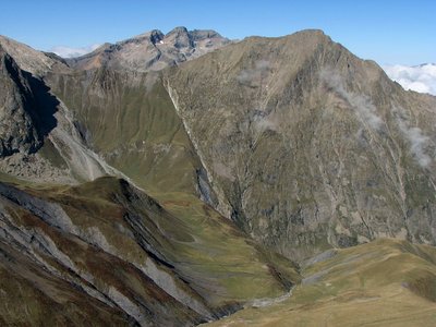
La faille de Ser Barbier - PNE - Albert Christophe  Geology and geography
Ser Barbier Fault
The fault at Ser Barbier brings into contact the crystalline bas (the needle of Venosc) and a marly deposit (Vallon mountain pass). It was formed during the Jurassic period when the Téthys sea opened out, by breaking and crumbling the crystalline massif. The rubbing together of the two parts created a beautiful striated mirror clearly visible due to erosion.
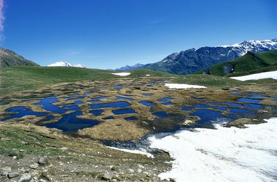
La tourbière de la Muzelle - PNE - Nicollet Jean-Pierre FloraMuzelle bog
The humid zone, which you cross just before Muzelle lake, is bursting with astonishing biodiversity. The remains of a big lake created during the retreat of the glacier, this marsh has become filled little by little with plants forming the biggest bog in Vénéon valley. For several generations, the shepherds have used the peat as a fuel. Today it is forbidden to extract it. The place is protected by fences as part of agri-environmental measures.
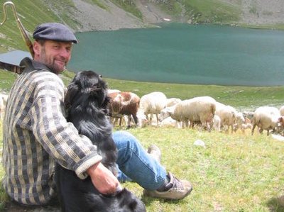
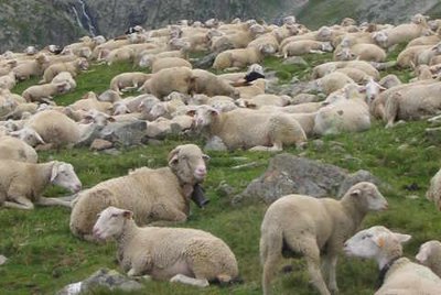
Pastoralisme au lac de la Muzelle - PNE - Brun André  Pastoralism
The pastoral valley
The configuration of the site made it very favourable to pastoralism for several centuries. This area of pastures was rented during the 19th and 20th centuries to seasonal grazers from the South of France. The local flocks from Venosc and particularly the flock from the hamlet of Laffreyte also went there. At that time, the first animals up in the mountain each year were the cows then the sheep. Since the 1980s, a flock of sheep of round 1200 animals from the Hautes-Alpes summer graze from June onwards and spend the summer in this prairie.
Pastoralisme au lac de la Muzelle - PNE - Brun André  History
A bit of history concerning the valley of Muzelle
At the end of the 19th century the forest was practically nonexistent, it had been reduced in favour of pastoral activity (on the higher planes) and for the culture of cereals, principally barley, above the inhabited areas. Towards 1945, the highest hamlets, like the one at Laffreyte above Bourg-d'Arud, were emptied of their inhabitant. Today the forest has gained ground covering the memory of a few ruins at the bottom of the track... Before the arrival of the motor car and the creation of roads, this itinerary around the lake and the Muzelle mountain pass was often used by the inhabitants of Venosc in order to cross the valley to the neighbouring valley of Valbonnais.
Altimetric profile
Sensitive areas
Golden eagle
- Impacted practices:
- Aerial, , Vertical
- Sensitivity periods:
- JanFebMarAprMayJunJulAug
- Contact:
- Parc National des Écrins
Julien Charron
julien.charron@ecrins-parcnational.fr
Peregrine falcon
- Impacted practices:
- Aerial, Vertical
- Sensitivity periods:
- FebMarAprMayJun
- Contact:
- Parc National des Écrins
Julien Charron
julien.charron@ecrins-parcnational.fr
Short-toed snake eagle
- Impacted practices:
- Aerial,
- Sensitivity periods:
- MarAprMayJunJulAugSep
- Contact:
- Parc National des Écrins
Julien Charron
julien.charron@ecrins-parcnational.fr
Short-toed snake eagle
- Impacted practices:
- Aerial,
- Sensitivity periods:
- MarAprMayJunJulAugSep
- Contact:
- Parc National des Écrins
Julien Charron
julien.charron@ecrins-parcnational.fr
Recommandations
Source

Report a problem or an error
If you have found an error on this page or if you have noticed any problems during your hike, please report them to us here: