10. From Saint-Léger-Les-Mélèzes to Gap Bayard
You will tread lovely, easy tracks, some grassy and sheltered through woods along the canal, others wide and open, culminating at the famous Gap-Bayard golf course.
Description
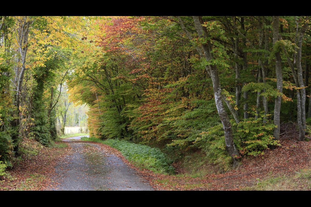
- Take the grassy path on the right which runs down along the edge of the forest, making the most of the view of the Chaillol mountains. Follow the PR (Petite Randonnée, short-distance trail) waysigns and head right downhill along a wooded path until you reach Le Tou. Turn left towards Bouscatu. The track is smooth and level, and it runs along the canal offering tunnels of shaded greenery. This canal runs through the mountain under the Col de Manse and re-emerges near the Lac des Jaussauds. It then carries on as far as Charance, 12 km away.
- In Bouscatu, head towards L'Are and then continue straight ahead towards Le Champ de Moïse. At the intersection with the Les Eyrauds track, take the level path opposite, still running along the canal side.
- Where it comes out onto the Communs track, turn left onto the level track and then immediately right onto a downhill path and fork left. The path comes out onto a new, drivable, track on a bend at the Communs. Carry on downhill until you come to Grand Pièce. Here, turn left onto the track on the right - perfect for a gallop - which brings you to the D514. When you come to the road, turn right downhill to the Appaloosa Farm and the Pont de Frappe. Cross the bridge over the Ancelle mountain stream and turn right onto the D114 heading towards Saint Julien. Then, at the branching junction, turn left towards the car park and then join "La Ligne", a never-completed railway line, at the "Courbe du Pont de Frappe", heading towards Serre-Richard.
- Carry on along the track and then cross the small road and continue straight ahead, still on "La Ligne". The track is now wide and level. Cross over the bridge spanning the Riou Gras. Further on, you pass underneath "La Bâche", a metal overhead canal that crosses the railway cutting. Where the paths intersect, continue straight on.
- In Serre-Richard, cross the Avenue de la République and then carry on along the uphill road opposite. Continue opposite along the Chemin des Forestiers. The track emerges on a bend in a road. Follow the road right.Cross the road and continue straight on.
- At the VTT and PR marker, fork right onto a wooded track and turn left at the Y fork. The grassy track (which is very rutted) comes out at the intersection of the Gap via tracks: follow the sign to the Gap Bayard Centre d'Oxygénation, along a dirt path which runs through the Bois de Saint Laurent, a remarkable beech wood. When it comes out onto the road, follow the PR waysign left on the track: you pass a cottage, the Cabanon de Campallon, and then the wet peatlands of La Sagne Staïse.
- At La Sagne de Canne, leave the mountain biking track and carry on along the road running downhill to the left. At Jearjat, go down the road on the left towards Gap Bayard.
- Leave this road at the junction and take the Bayard forest road on the left, which takes you into wooded aisles through the golf course on the Bayard plateau. Stay on the main track, following the running route, to complete the circuit at the car park where you started out.
- Departure : St Léger-Les-Mélèzes
- Arrival : Gap Bayard
- Towns crossed : Saint-Léger-les-Mélèzes, Chabottes, Forest-Saint-Julien, Saint-Laurent-du-Cros, and Gap
3 points of interest
 Architecture
Protestant Church of Saint-Laurent du Cros
This is the only Protestant church in the Champsaur and it witnessed the dark period that followed the Revocation of the Edict of Nantes in 1685. Today, with the religious wars firmly in the past, this building is a place of worship and assembly for the valley's Protestants.
Prior to 1685, there were three Protestant churches in the territory, in Saint-Bonnet, Orcières and Ancelle. At that time, when the Duke of Lesdiguières, Jean-François de Bonne, was extending his rule over the Champsaur, Protestants represented a significant proportion of the population. Since this major figure was also the leader of the Protestants, forced conversions were common. But when Louis XIV decided to revoke the Edict of Nantes, all over France pastors were hanged, shot and sometimes sent to the galleys, and Protestant churches were destroyed. In 1789, freedom of religious practice was finally restored.
In the valley, it was not until 1834 - and a ministerial order allocating the sum of one thousand francs for this purpose - that a new church for adherents of the Reformed Church was constructed. But by 1880 the building had become too small and a new church, inaugurated on 26 May 1886, was constructed on its present site, provided by Mr Victor Cesmat.
In 2003 significant restoration work was carried out by the municipality on the entire building.
 Fauna
FaunaMouflon
If you make a detour to the Col de Gleize, you may well see some mouflons. An ancestor of the sheep with ammonite horns, it was introduced from 1949 into the Alps from herds in Corsica and central Europe, and seems well settled in the Chaudun area. Even though the European Union recommends strict protection of the mouflon, it is still hunted during the hunting season. Its populations are ill-adapted to extreme Alpine conditions and can fluctuate according to the winter weather.
 Panorama
Bayar golf course
The Gap-Bayar golf course is located at an altitude of 1,250m. In the view of specialists, it is one of the finest golf courses in the south of France. The 18-hole course is surrounded with forests filled with wild fruit, mushrooms and wild animals. Near the pastures, where the cows graze, there is a clear view over the Champsaur, the Ecrins and the town of Gap.
Altimetric profile
Report a problem or an error
If you have found an error on this page or if you have noticed any problems during your hike, please report them to us here: