3. The refuges of Les Mouterres and Le Fay via the Plateau d'Emperis
This stage comes to a close in complete tranquillity, lulled by the waters of the Romanche river, outside the small hamlet of Les Fréaux, a source of inspiration for numerous artists.
Description
- Follow the first footpath on the right (off the GR) which leads to Lac Noir and Lac Lerié. Poorly marked initially, the footpath first takes you to the small crystalline lake (2,360m) across a stretch of bouldery terrain. Continue uphill until you reach a flat area, ignoring the path leading off to the left, and you come to the shores of Lac Noir. Carry straight on due east until you come to Lac Lerié. At the next intersection, ignore the right-hand path to rejoin the GR54 downhill from the Col du Souchet.
- Take the GR54 on the right. Cross the Rif des Caturages and Rif de Galan at the foot of the Serre Bernard and pass above the ruins of Pré Veyraud. Continue underneath the Le Plateau ski lift.
- Ignore the narrow path on the left which leads to the hamlet of Le Clot Raffin. Continue downhill on the steeply winding path (ski lift) leading down to the bridge over the mountain stream Le Gua (1,735m). The road on the right leads to Le Chazelet.
- When you come to Le Chazelet, take the first road on the right which skirts around the village. Then follow the Paul Louis Rousset (No. 16) footpath and you arrive at Les Fréaux after crossing the local road. Then follow the mountain stream as far as the intersection with a road.
- Turn left along the local road and then cross the river Romanche.
- Go left along the narrow paved road (D233) following it for approximately 2km.
- Turn left and once again cross the Romanche to reach La Grave and your starting point (cable car car park).
- Towns crossed : Mizoën and La Grave
6 points of interest
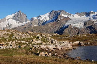
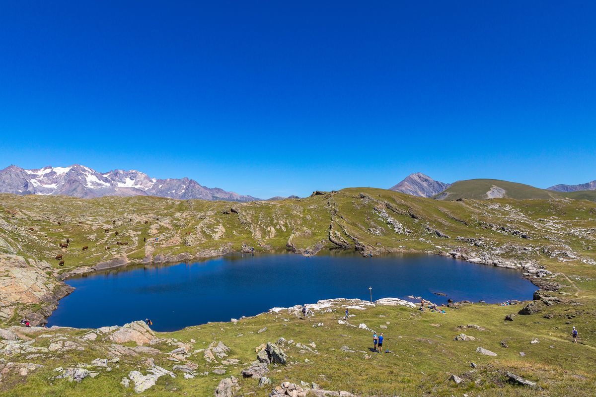
Troupeau d'ovins sur le plateau d'Emparis - Denis Fiat - PNE  Panorama
The Emparis Plateau
The mule path follows the edge of the Southern border of the plateau which is completely dedicated to pastoralism and tourism. It offers an exceptional view of the Meije whose marked relief contrasts with this gentle landscape. It welcomes 7 refuges and pastoral cabins as well as remarkable fauna, like the Mountain Hare and the Mountain Apollo butterfly. The challenge for this site is to preserve its pastoral character.
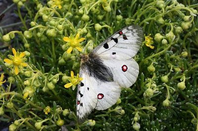
Petit apollon sur sa plante hôte (saxifrage faux aizoon) - Bernard Nicollet - PNE  Fauna
FaunaSmall Apollo
The Small Apollo is a rare and protected butterfly. It has finely striped black and white antennae, and a tiny red ocellus (eye) on each of its forewings. With a wingspan of 60 to 80 mm, it is the lord and master of the orangey-yellow beds of mountain saxifrages where it takes care of its eggs and feeds its caterpillars.
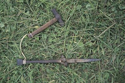
L'enclume et le marteau pour battre la faux - Cyril Coursier - PNE  Know-how
Agricultural work in Spring and Summer
In Spring the soil had to be moved up the land using crates pulled by mules. Ploughing, sowing, planting followed rye (which stayed in the ground for two years), barley, oats and potatoes. Summer was not finished until the barns were full of hay. Scythes that had been beaten on an anvil, rakes, and nets were used every day. In order to ensure the overwintering of the animals, a certain number of loads (around 80 kg of hay) were necessary: 25 for each dairy cow and 5 for each sheep.
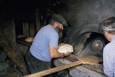
La cuisson du pain noir - Jean-Pierre Nicollet - PNE Know-howAgricultural work in Autumn and Winter
From September, cereal crops were cut with the scythe and the sickle, dried in “bourles” (small stacks of ten sheafs) on the top of the land (fields). Once beaten, the grains of rye were dried in the sun «soleillaient », they were taken to the mill and then to the oven to be made in to black bread. From the end of November until the beginning of May, the animals had to be tended to in the stables. The manure from the cows was transported to the fields using sledges, while the sheep dung was dried and cut in to, pieces, and burnt to produce heat and energy for cooking. In the dairy, milk was made in to butter and cheese.
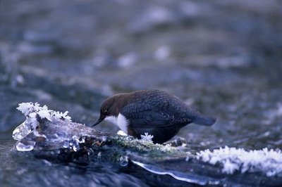
Cincle plongeur - Robert Chevalier - PNE FaunaWhite-throated dipper
Perched on a large, partly immersed pebble, the dipper sways to and fro with its tail aloft, and then dives down head first into the swirling water. This surprising passerine is unusual in moving underwater against the current in search of food. Thanks to a thin membrane protecting its eyes from the water, it can spot its prey (worms, small shellfish, water insect larva), before lifting its head out of the water and letting the current carry it gently along. It then takes up a new surveillance position and starts the process all over again.
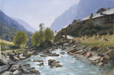
Les Fréaux près de la Grave, Charles Bertier - © Musée de Grenoble  History
Les Fréaux près de la Grave, Charles Bertier
The Romanche valley was a source in inspiration for numerous painters of mountain landscapes. It inspired Charles Bertier (1860-1924) to paint the oil on canvas Les Fréaux près de la Grave in 1894. Introduced to landscape painting by J. Achard and to mountain landscape painting by Laurent Guétal (who was a priest so was also known as L'Abbé Guétal) this Grenoble-born artist thought nothing of setting up his easel on the highest peaks of the Dauphiné Alps. With canvases such as L'approche de l'orage en Oisans (1900), he made it his mission to give his contemporaries an understanding of the mountains.
Altimetric profile
Sensitive areas
Golden eagle
- Impacted practices:
- Aerial, , Vertical
- Sensitivity periods:
- JanFebMarAprMayJunJulAug
- Contact:
- Parc National des Écrins
Julien Charron
julien.charron@ecrins-parcnational.fr
Short-toed snake eagle
- Impacted practices:
- Aerial,
- Sensitivity periods:
- MarAprMayJunJulAugSep
- Contact:
- Parc National des Écrins
Julien Charron
julien.charron@ecrins-parcnational.fr
Information desks

Oisans Park house
Rue Gambetta, 38520 Le Bourg d'Oisans
Video presentation of the natural resources of the Oisans mountain and its crafts. Information, documentation about the Park, projections, reading space for children. Accessible to people with reduced mobility. Free admission. All animations of the Park are free unless otherwise stated.

Tourist information office of La Grave
RD1091, 05320 La Grave
Opening hours:
- May to mid-June: from Tuesday to Saturday from 9 am to noon and from 2 pm to 5 pm.
- Mid-June to mid-July and mid-August to mid-September: Monday to Saturday from 9 am to noon and from 2 pm to 5.30 pm.
- Mid-July to mid-August: every day from 9 am to noon and from 2 pm to 5.30 pm.
More information
Source

Report a problem or an error
If you have found an error on this page or if you have noticed any problems during your hike, please report them to us here: