From Gap Bayard to Le Domaine
Gap MediumDifficulty
1. From Gap Bayard to Le Domaine
6h30
Duration25,8km
Distance+736m
Positive Elevation-890m
Negative ElevationStage
Course typeNetwork
Embed this item to access it offline
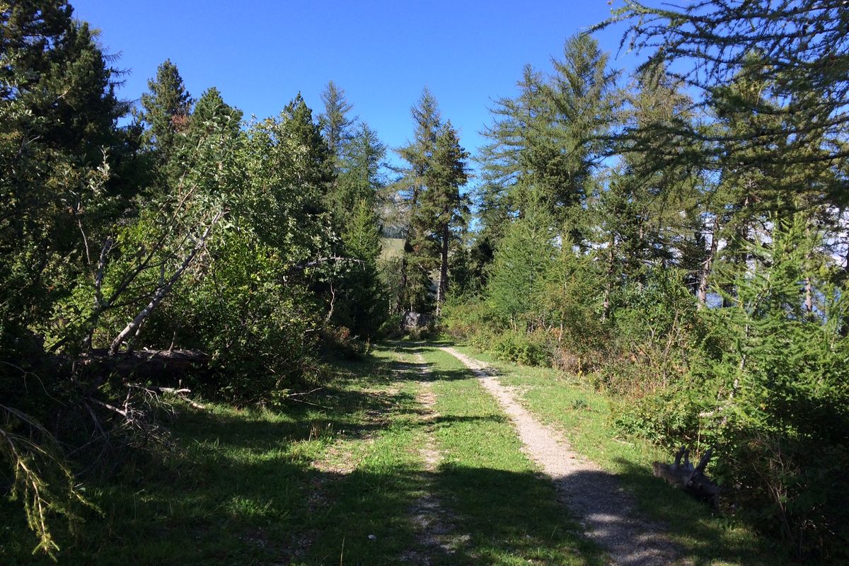
As you wind uphill, you are offered scenic views of the Gap basin and the surrounding peaks. Then, you enter the forest in which there are occasional gaps offering glimpses of the Champsaur area criss-crossed by trees and hedgerows or Le Vieux Chaillol. Further on, at Notre-Dame de Bois-Vert, a more cultural break awaits although the panoramic view is no less remarkable. The stage ends by following the banks of the Drac, enjoying its freshness and the serenity it imparts.
Description
From the start car park, head south through the woods along the N85.
- Leave the sports trail and head down towards and cross the N85. Follow the road southwards for 100m.
- Take the 1st right onto the Route de la Mémoire. Take the 1st turning on the right.
Branch off towards Les Sérigues and Les Brunets on a road/trail that winds upwards. Enjoy the view of the Gapençais basin, the tête de Clappe, the Chapeau de Napoléon, the puy de Manse, the Piolit, the Aiguilles de Chabrière, the Saint-Mens hill, the Avance with Mont Colombis and the peaks of the Ecrins massif. - Go past the Brunets junction and turn right onto the Brunets forest road (PR, D54 track).
> This is a possible stopover at ‘Une Cabane pour Deux’, with no detours.
Leave the PR route temporarily to avoid the guard dogs and join another PR route to the Col de Gleize, located between the Courmian and Gleize peaks. - Take the wide, flat, grassy PR trail to the right of the Folletière hut towards Notre-Dame de Bois-Vert. Walk under the Gleize peak and the Aiguille peak. The track joins the Lauzon forest road after a sharp bend and continues through the larch forest.
At Clot du Lauzon, continue on this pleasant main track towards Lauzon and the Laye resort, where the view of the Bayard plateau and the Champsaurin bocage is breathtaking.
At Le Lauzon, continue towards the resort of Laye. As you cross the ski slopes, enjoy the view of Vieux-Chaillol opposite.
> Possible access for a stopover at Maison l'Aiguille, see end of description.
Continue towards the coulée des Adroits and head towards La Cuque. - At the lookout point at La Cuque, an ONF sign provides information on the area's geography, hydrology, relief, climate and vegetation. Admire the panorama of the typical Champsaur hedgerows.
Continue in the direction of the Clot des Fascines along the charming La Cuque path through the undergrowth.
At Le Devès, an ONF sign explains the biodiversity of the forest.
Pass through Le Devès, Sagnassou, les Croussières, les Selliers and les Farelles, where the Régina breeding farm offers endurance Arab thoroughbreds. - Before leaving the hamlet of Les Farelles, take the track on the left, through undergrowth and closed to motorised vehicles, which leads to Notre-Dame de Bois Vert. Here, the chapel, cemetery, statues, bell tower with exhibition canopy, oratory, cenotaph, fountains, tables and benches, grass and shade invite you to take a cultural break and/or enjoy a picnic.
- At Notre-Dame de Bois-Vert, take the grassy path on the right, between the small cemetery and the large cross. Once you reach the road, continue down the Chemin de Bois-Vert, cutting the twists and turns in the road by the tracks alongside the farms, whose tiled roofs you can admire.
At Sous la Fare, when you reach the road, continue straight on and cross the torrent de la Fare towards Poligny.
At Les Martins, continue along the Route du Chatelard, then take the first grassy track on the right. This track leads to a housing estate (chemin de la Casse): continue straight on to Les Allards. - Turn right onto the route des Allards towards Les Baraques. Before the large roundabout, fork left towards the small car park and fountain and cross the N85 to continue along Rue du Pont. At the end of the road, turn left onto the bridge over the Drac.
- At the end of the bridge, take the first road on the right towards Carrefour Market. Continue straight on, passing the veterinary clinic and taking the bridge over the Riou Maffren. Then walk along the Drac on the flat, comfortable path that starts to the right of the water treatment plant building.
- Before reaching the Champsaur lake, a path hidden by an embankment climbs up through the grass to the left, alongside the meadows. It becomes a track (chemin de Dabou) and, continuing straight ahead, leads to the D945 (fast-moving traffic): turn right along the road, then cross over and climb the route de Coste Joffre towards the Marie Philip holiday centre: a stopover for the night.
- Departure : Gap Bayard
- Arrival : Le Domaine
- Towns crossed : Gap, Laye, La Fare-en-Champsaur, and Saint-Bonnet-en-Champsaur
1 point of interest
 Know-how
ONF
The work of the Office National des Forêts (National Forestry Office) is not limited to the forests. After buying a large amount of land following the rural exodus (public land), the state delegated to the Water and Forestry agency the difficult task of preserving the natural heritage of a large number of areas (restoration of land and building, maintenance of paths, etc.)
Altimetric profile
Sensitive areas
Along your trek, you will go through sensitive areas related to the presence of a specific species or environment. In these areas, an appropriate behaviour allows to contribute to their preservation. For detailed information, specific forms are accessible for each area.
Golden eagle
- Impacted practices:
- Aerial, , Vertical
- Sensitivity periods:
- JanFebMarAprMayJunJulAug
- Contact:
- Parc National des Écrins
Julien Charron
julien.charron@ecrins-parcnational.fr
Peregrine falcon
- Impacted practices:
- Aerial, Vertical
- Sensitivity periods:
- FebMarAprMayJun
- Contact:
- Parc National des Écrins
Julien Charron
julien.charron@ecrins-parcnational.fr
Report a problem or an error
If you have found an error on this page or if you have noticed any problems during your hike, please report them to us here: