From Rousset to Chorges
Rousset HardDifficulty
4. From Rousset to Chorges
5h
Duration30,9km
Distance+1178m
Positive Elevation-1193m
Negative ElevationStage
Course typeNetwork
Embed this item to access it offline
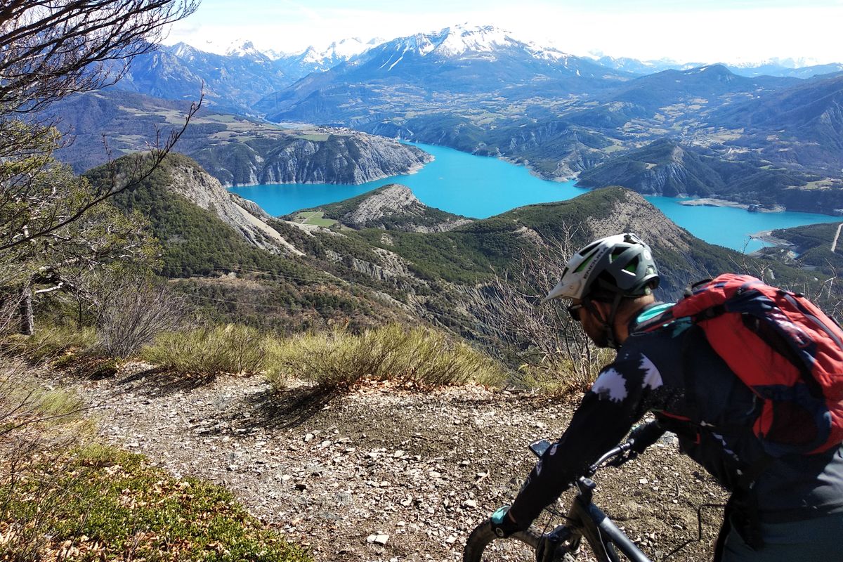
This stage undoubtedly offers the finest views over the lake, with Le Ruban, the balcony of the Col Lebraut and Peyre Grosse. Get ready to experience the satisfaction and sense of achievement of reaching a hard-won summit and gazing in admiration over a serene panorama. And, as a bonus, the thrills to be had on these twisting and turning trails.
Description
At the roundabout in Espinasse, turn right towards Rousset. After the belvedere, head uphill to the left and go through the village.
- At the Col de Pré du Laus, head uphill to the right and at the second hairpin bend continue left. Ride through the solar power plant.
- At the container, head uphill to the right and stay on the main track which takes you to the hamlet of Vière (you can carry straight on along a yellow waymarked technical trail and going through Les Counitous).
- After the descent from Vière, climb up the track on the right until you come to the Col de la Croix des Prés. At the col, take the first right (track 80) heading towards Clot Clavary. At the branching junction, head left uphill through a larch wood.
- At the Clot Clavary refuge hut, head uphill on the rightmost path (the "Chemin de la Procession") (pushing might be required). Then stay on the ridge path: "Le Ruban".
- At Le Clos Charmantier, take the downhill path opposite, heading towards Rousset. After a short descent, head uphill again to the left on the forest path. - On the descent, slow down to take a trail on the left which cuts through the bends.
- When you come to a trail, turn left towards the Col Lebraut until you come to the road. Head downhill to the right which takes you to the col.
- At the Col Lebraut, follow the road right for 50 metres and then turn left to join the trail leading up the hill. (Some pushing). At the RD3, head down the track on the right. At the end of the ridge, turn left onto the "Les Yvans" trail (take care, technical trail).
- At the multisports faciity ("plateau omnisport") at the holiday centre, turn left and left again and head up the road (D403). At a car parking area, follow the downhill trail on the right until you come to the road below. Follow this left for a few metres and then turn right: carry straight on along the trail. Under the high voltage line, take the trail on the right.
- Turn right and then right again onto the road, heading towards Chorges (RD3). At the holiday centre, Les Horizons-du-Lac, turn left and then take the first right. At the hamlet of Le Villard, head uphill on the path on the left. After the railway underpass, turn left onto the old road which takes you to Chorges.
- Towns crossed : Rousset, Espinasses, and Chorges
1 point of interest
Torrent d'addos - Amélie Vallier  Water
WaterAddos mountain stream
The Addos mountain stream (torrent in French) is 4 kilometres long. A mountain stream is a natural water course located in the mountains. The flow regime is characterised by a steep gradient, with a very fast and therefore turbulent water flow producing significant erosion. It is also defined by a significant variation in flow rate depending on precipitation levels. In this mountain stream, as in many others, numerous small sills (small dams) have been created to slow down the water flow and limit the impact of floods.
Altimetric profile
Recommandations
Take care on the descent from Le Ruban and before the Écrin du Lac estate.
To avoid the very technical descent, turn left at the Col Lebraut.
Pleasant picnic stops at the Col des Prés, Le Ruban and Peyre Grosse.
To avoid the very technical descent, turn left at the Col Lebraut.
Pleasant picnic stops at the Col des Prés, Le Ruban and Peyre Grosse.
Information desks
Les Celliers, 05190 Rousset
Source

Parc national des Ecrinshttps://www.ecrins-parcnational.fr
Report a problem or an error
If you have found an error on this page or if you have noticed any problems during your hike, please report them to us here: