From Chorges to Embrun
Chorges HardDifficulty
5. From Chorges to Embrun
4h30
Duration40km
Distance+1142m
Positive Elevation-1208m
Negative ElevationStage
Course typeNetwork
Embed this item to access it offline
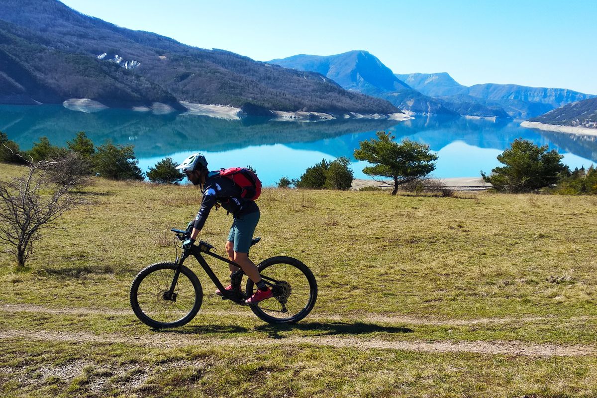
Against the backdrop of the southern slopes of the Aiguilles de Chabrière and Mont Guillaume, this route runs from inlet to inlet, alternating between fun trails along the lake shore, pine woods and delightful beaches! Take to the heights to enjoy panoramic views over the whole lake. The final stretch is a "must-ride" descent of the Embrunais area: the famous "Descente des Tourniquets".
Description
At Prévalier, turn right and then right again towards the Baie Saint-Michel and then the Baie de Chanteloube.(D3). Leave the D3 and go left up the road towards Malmiellon. At the chapel of Chanteloube, head down the road on the right. After the bridge, take the road on the right.
- At the car park in Chanteloube, take the small paved road leading to the "Dunes" ridge. At Le Serre de l'Aigle, go straight on and then head uphill right and then right again on the tracks. At Les Devandines, head left downhill.
- At Champ de Gorny, take the downhill trail opposite towards the Baie Saint Michel. At Le Mas des Bâtardes, take the road on the right. Carry straight on towards Aquaparc. Before the campsite entrance, take the trail on the left (/!\ steep slope).
- At the car park at the Baie de Saint-Michel head up the road on the left to the treetop adventure park. Cross [the right-hand side] of the Marasse car park, and take the downhill trail on the left heading towards Mauduech (some pushing). Then stay on the small road until you come to the N94. Go along the right-hand side of the N94 (take care) and enter the lay-by area. Go through the gate and head downhill to the right. After 150 metres, turn left onto the hairpin trail. You reach the car park in Mauduech via the main trail (Some pushing). At the car park, take the road on the right /!\ (RN94).
- At the road to the Camping du Roustou, take the service road opposite. Do not go downhill towards the lake, but climb uphill on the path on the left. Be alert, a trail winds off in hairpins to the left (viewing point) and runs under the road. Follow the mountain stream uphill and take the path on the right heading towards the building. At the four-track intersection, take the right-hand path which takes you to the road. Turn left uphill.
- At the Pra Perrier crossroads, turn right onto the uphill path. Stay on the level track and then head downhill through the pines. When you come to the old road, head right downhill. On a right-hand bend, take a left to enter the Mont Guillaume forest. Ride along the shore of the Baie du Clot Olivier.
- Before the SNCF railway bridge, turn left uphill. At the Mazet ravine, take the downhill trail on the right which takes you to a vineyard hut. Turn right and this takes you to the hamlet of Les Villards. At Roubeyères, head right down the road. Stay on the D41 until you come to the roundabout: Go straight on onto the RD641 heading towards Puy-Sanières.
- In La Rochette, after the climbing site car park, go down the road on the right and, before the bridge, take the trail running downhill to the left. When you come to a path, turn right up the Côte de l'Orme hill. At the branching junction, continue heading left uphill. At the crossroads down from the water treatment plant, take the uphill route on the right, along the track DFCI g38. Stay on the path, taking options leading left until you come to the road.
- At the belvedere of Le Pibou, take the first DFCI track on the right. Carry straight on until you come to the hamlet of Les Bouteils. Turn right towards the gîte "Au Fil de l'Eau" at 400 m. Leave Puy-Sanières heading right downhill along the RD309. On the left-hand bend, take the "Descente des Tourniquets". After the bridge, take the path on the left.
- At the lakeside gardens, after the bar, turn right towards the water sports centre ("Base nautique") and back to the lake via the dam track ("Chemin de la Digue").
- Towns crossed : Chorges, Prunières, Savines-le-Lac, Saint-Apollinaire, Puy-Sanières, and Embrun
6 points of interest
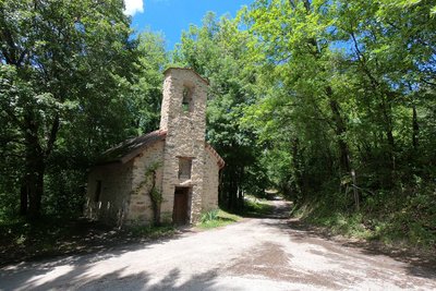
Chapelle St Jacques - Amélie Vallier  Vernacular heritage
Chapel of St-Jacques
Located in Chanteloube, this church is through to date back to 1510. It has retained all its authenticity, with its exposed stone. It is dedicated to Saint James, one of the 12 apostles and one of the first martyrs of the Catholic church. Its recent restoration has made it possible to hold the traditional celebrations there, in honour of Saint James. The purpose of each one is to commemorate a historical event connected with the saint. When he died, he was taken to Compostella in Spain, hence the name of the pilgrim's Way of Saint James to Santiago de Compostella, a religious route passing along the shores of the Serre-Ponçon lake.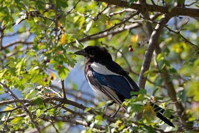
Pie bavarde - Pascal Saulay - PNE  Fauna
FaunaCommon magpie
This bird can be identified by its black and white plumage with blue-green tints on the wings and tail. Its tail is remarkably long. It can be found all year round in varied open environments. Its omnivorous diet consists of invertebrates, seeds and berries, small rodents, eggs and nestlings and even human rubbish. Except during the nesting period when it is solitary, the magpie is gregarious species which gathers into rather raucous groups in the winter.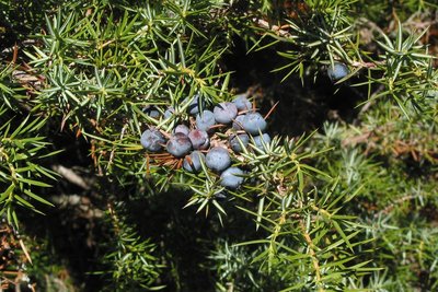
Genévrier commun - Jean-Pierre Nicollet - PNE  Flora
FloraCommon juniper
This bush is a resinous evergreen conifer. It is characterised by its greenish to blue (glaucous) needles with a white line on their upper side, and fruits resembling blue-black berries. It usually tends to grow in warm environments receiving plenty of sunlight. It grows in grassy or scrub covered areas up to 2,000 metres above sea level.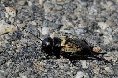
Grillon Champêtre - Mireille Coulon - PNE FaunaThe field cricket
Just 18 to 26 mm long, this little insect has a black head which looks a little like a helmet. The female can be told apart from the male by the presence of a third long appendage at the rear of the body. The cricket’s song is heard from April onwards. The male sings his chirping song from the entrance to his burrow. The fertile females lay their eggs in the ground, which remain there for two weeks before the larvae emerge.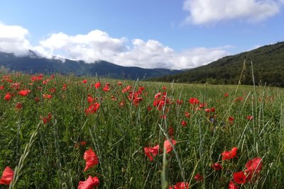
les méssicoles - Amélie Vallier FloraMessicole plants
A feature of messicole plants is that they live among crops, even though not sown there deliberately. They are biologically adapted to open areas, and in particular areas that are regularly worked, such as fields. In fact, they use various strategies such as adapting their life cycle and producing large amounts of seeds in order to make up for the disturbance that occurs in their germination area. Many of them are common, such as the poppy, the cornflower and the corn buttercup...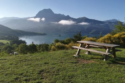
Panorama Baie st Michel - Amélie Vallier  Panorama
Panorama of the Baie Saint-Michel
This area, which has been provided with picnic amenities, offers the most picturesque panorama over the Lac de Serre-Ponçon. In fact, the lake is 2 kilometres wide at this point, and in front of you are the Chapelle Saint Michel and the Pic Morgon, an iconic view of the lake. On your left, to the east, you can see Savines-le-Lac and its bridge. On the right, you can see the secret île de la Tortue.
Altimetric profile
Sensitive areas
Along your trek, you will go through sensitive areas related to the presence of a specific species or environment. In these areas, an appropriate behaviour allows to contribute to their preservation. For detailed information, specific forms are accessible for each area.
Short-toed snake eagle
- Impacted practices:
- Aerial,
- Sensitivity periods:
- MarAprMayJunJulAugSep
- Contact:
- Parc National des Écrins
Julien Charron
julien.charron@ecrins-parcnational.fr
Short-toed snake eagle
- Impacted practices:
- Aerial,
- Sensitivity periods:
- MarAprMayJunJulAugSep
- Contact:
- Parc National des Écrins
Julien Charron
julien.charron@ecrins-parcnational.fr
Recommandations
There are numerous activities on offer at Chanteloube and in particular the Baie Saint-Michel: bathing, paddle, adventure park etc. Take care on the short sections of main road and on the Descente des Tourniquets. Before Mauduech it is possible to picnic in the shade of the pine trees. E-bikes can be charged at the bar-restaurant at the Le Roustou campsite.
Information desks

Tourist office Chorges
Grand rue, 05230 Chorges
October to may : Monday to Saturday, 9.00 - 12.30 & 13.30 - 17.00.
April, may, june & september : Monday to Saturday, 9.00 - 12.30 & 14.30 - 18.00
July and August : Monday to Saturday, 9:00 – 12.30 & 14.30 – 19.00 Sunday 9.30 – 12.30
Closed on Thursdays outside French holidays’ periods
Closed on French national holidays, except 14th of July and 15th of August
Source

Parc national des Ecrinshttps://www.ecrins-parcnational.fr
Report a problem or an error
If you have found an error on this page or if you have noticed any problems during your hike, please report them to us here: