From Chapelle-en-Valjouffrey to Valsenestre
Valjouffrey EasyDifficulty
1. From Chapelle-en-Valjouffrey to Valsenestre
2h
Duration5,1km
Distance+354m
Positive Elevation-43m
Negative ElevationStage
Course typeEmbed this item to access it offline
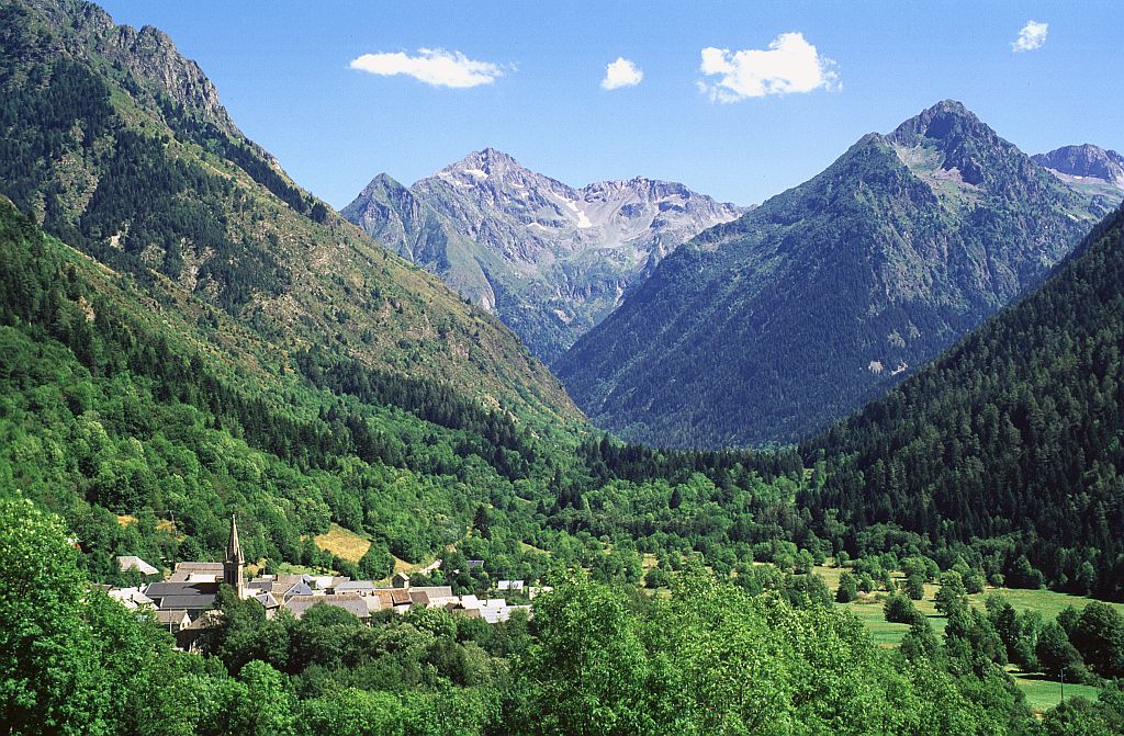
After a steep start above the hamlet of La Chapelle-en-Valjouffrey, the almost exclusively forested route weaves along the left bank of the Béranger torrent. The path, often narrow, rarely sloping, alternates between sections overlooking the torrent and less steep sections.
Description
From the car park at the downstream entrance to La Chapelle-en-Valjouffrey, join the RD117. Follow it to the right for around ten metres, then turn left onto Rue de l'église. At the “sur la Chapelle - 980m” crossroads, head for Valsenestre. The path starts with a steep and short flight of concrete steps, then rises rapidly above the hamlet, before skirting the Béranger torrent.
- After about 2km, the path approaches the torrent. Stay on the left bank. Then tackle a longer climb, with a few hairpin bends, to the saw bridge (follow signs for Valsenestre).
- After another climb and another flat spot, the path joins a track. Follow it to the right for a few metres. The path then turns off to the left.
- After several hairpin bends on a stony path where the remains of old low walls can be seen, the path crosses a gullied area where a temporary torrent flows (ford crossing). After a short descent, the path joins a grassy track and the Valsenestre meadows.
- Join the RD117A, which you follow for 600 metres until you reach Valsenestre.
- Departure : La-Chapelle-en-Valjouffrey
- Arrival : Valsenetre
- Towns crossed : Valjouffrey
Altimetric profile
Sensitive areas
Along your trek, you will go through sensitive areas related to the presence of a specific species or environment. In these areas, an appropriate behaviour allows to contribute to their preservation. For detailed information, specific forms are accessible for each area.
Golden eagle
- Impacted practices:
- Aerial, , Vertical
- Sensitivity periods:
- JanFebMarAprMayJunJulAug
- Contact:
- Parc National des Écrins
Julien Charron
julien.charron@ecrins-parcnational.fr
Short-toed snake eagle
- Impacted practices:
- Aerial,
- Sensitivity periods:
- MarAprMayJunJulAugSep
- Contact:
- Parc National des Écrins
Julien Charron
julien.charron@ecrins-parcnational.fr
Recommandations
Easy, but sometimes narrow and vertiginous on some sections.
Is in the midst of the park
The national park is an unrestricted natural area but subjected to regulations which must be known by all visitors.

Information desks

Maison du Parc du Valbonnais
Place du Docteur Eyraud, 38740 Entraigues
Reception, information, temporary exhibition room, reading room and video-projection on demand. Shop: products and works of the Park. Free admission. All animations of the Park are free unless otherwise stated.
Transport
Access and parking
D26 from La Mure. D526 from Pont du Prêtre. D117 from Entraigues to la Chapelle-en-Valjouffrey.
Parking :
Car park at the downstream entrance to La Chapelle-en-Valjouffrey
More information
Source

Parc national des Ecrinshttps://www.ecrins-parcnational.fr
Report a problem or an error
If you have found an error on this page or if you have noticed any problems during your hike, please report them to us here: