From Temple-Écrins refuge to Pic Coolidge via the Col de la Temple (mountaineering)
Voie normale du Pic Coolidge
Voie normale du Pic Coolidge - Thierry Maillet - PNE
Saint-Christophe-en-Oisans

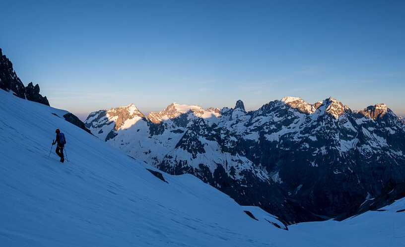
2. From Temple-Écrins refuge to Pic Coolidge via the Col de la Temple (mountaineering)

History and architecture
Lake and glacier
Panorama
Grade F+ (35° on snow and II/III on rock), long mixed climb (snow/rock) with some rocky stretches of moderate difficulty, no crevassed glacial terrain.
Embed this item to access it offline
The Pic Coolidge is the ideal place to start mountaineering. This accessible route also offers a unique panorama of the Écrins.
To climb the Pic Coolidge is to follow in the footsteps of the man who put the massif on the map, the Reverend William Augustus Brevoort Coolidge, during the great era of the conquest of the Alps between the 19th and 20th centuries. At the summit, a sumptuous panorama opens up over the peaks of the Écrins, including the majestic Barre des Écrins and Mont Pelvoux. Breathtaking!

Description

From the refuge, follow the Pilatte valley trail. At 2,484 m, fork south to enter another small valley. Cross the escarpments dropping down from the SW arete of Pic Coolidge, heading SE. The trail then follows the right-hand bank (numerous cairns) eventually coming to the N side (around 3,180 m) of the terminal slope under the Col de la Temple, suspended above a rocky ridge. The ascending traverse (30/35° maximum) runs through either snow or the rocks at the base of the snow (later in the summer). You reach the col and then the shoulder 3,321 m on the ridge line, 100 m to the N of the topographic col (3,301 m). From the shoulder, it is easy to follow the ridge northwards. At the foot of the S arete, a ledge rises diagonally to the right on the E slope (towards the NE). Follow this until you reach the final couloir which leads to a small breach below the edge of the S arete. Continue on the E slope. Follow a ledge system, pass through the breach 3,410 m and you reach the higher plateau. Go up this until you come to the arete to the W of the col 3,682 m. Climb the E arete on the S flank (potentially mixed) until you come to the S fore-peak. The main summit 100 m to the N is reached via an aerial but easy arete (descent in a breach, 2b on rock/mixed)
The descent is via the same route in reverse.

For more information, please refer to the book ‘Voies normales et classiques des Écrins’ by Sébastien Constant.
  • Departure : Temple-Écrins refuge
  • Arrival : La Bérarde
  • Towns crossed : Saint-Christophe-en-Oisans and Vallouise-Pelvoux

1 point of interest

  • Le refuge Temple-Ecrins
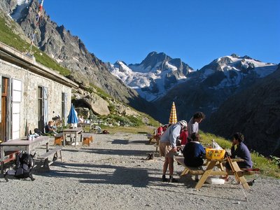
    Le refuge Temple-Ecrins - © Parc national des Ecrins - Jean-Pierre Nicollet
    Hut

    Temple Ecrins Refuge

    Half buried on a fine plateau facing the most beautiful peaks of the mountain range, the Temple-Ecrins Refuge takes its name from the Col de la Temple, a little higher up, and from the famous Barre des Ecrins, the highest point in the range, looking down on it. Like many other refuges in Oisans, the first was built in 1925. It was made of wood and was a little higher up than the present-day refuge. It was destroyed by an avalanche 13 years later. It was only rebuilt in 1947 by the "Jeunesse et Montagne" organisation. The refuge is easy to access and is the goal of a fine family hike rounded off by a hearty meal and the starting point of such famous Alpine races as the Col de la Temple, the Pic Coolidge or the Face Nord de la Barre.


Altimetric profile


Sensitive areas

Along your trek, you will go through sensitive areas related to the presence of a specific species or environment. In these areas, an appropriate behaviour allows to contribute to their preservation. For detailed information, specific forms are accessible for each area.

Golden eagle

Impacted practices:
Aerial, , Vertical
Sensitivity periods:
JanFebMarAprMayJunJulAug
Contact:
Parc National des Écrins
Julien Charron
julien.charron@ecrins-parcnational.fr

Golden eagle

Impacted practices:
Aerial, , Vertical
Sensitivity periods:
JanFebMarAprMayJunJulAug
Contact:
Parc National des Écrins
Julien Charron
julien.charron@ecrins-parcnational.fr

Recommandations

In the descriptions, you will find elevations which are intended as a reference point to locate your position on a gradient or slope. These should be taken with a margin of error (~ +/- 30 metres), especially where they are not set or referenced by the IGN. In the last resort, it is your own experience that will guide you when, maybe at the foot of five dihedral corners all indistinguishable from one another, you are complaining bitterly about your guidebook or even a friend's sketch. It would be difficult to grasp all the complexity of a route using just a description or a photo view of the route. Only the three aids together (description/photo with a route overlay/IGN map) will give you a comprehensive picture.
The conditions of a route or the mountain can change, and sometimes the description will differ from what you encounter on the ground. Be your own guide. These descriptions are not absolute reality and sometimes intuition will serve you better than a guidebook. So BONNE ROUTE, with or without a map to lead you through the maze!

From the book by Sébastien Constant (2007), Voies normales et classiques des Ecrins, Éditions Constant, L'Argentière-la-Bessée, p. 18.
Standard equipment for snow and mixed itineraries, not including glacial terrain: telescopic poles, crampons, ice axe, helmet, harness, 30m climbing rope, belaying and progress equipment, 30-litre bag, warm clothing, safety kit etc.
Is in the midst of the park
The national park is an unrestricted natural area but subjected to regulations which must be known by all visitors.


Information desks

, 38520 Saint-Christophe-en-Oisans - La Bérarde

http://www.berarde.com/infos@berarde.com04 76 80 50 01

Oisans Park house

Rue Gambetta, 38520 Le Bourg d'Oisans

http://www.ecrins-parcnational.fr/oisans@ecrins-parcnational.fr04 76 80 00 51


Video presentation of the natural resources of the Oisans mountain and its crafts. Information, documentation about the Park, projections, reading space for children. Accessible to people with reduced mobility. Free admission. All animations of the Park are free unless otherwise stated.

Find out more

More information


Source

Parc national des Ecrinshttps://www.ecrins-parcnational.fr

Report a problem or an error

If you have found an error on this page or if you have noticed any problems during your hike, please report them to us here:


Trail news