Meije Orientale (3,891m)
Villar-d'Arêne HardDifficulty
Meije Orientale (3,891m)
2j
Duration15,3km
Distance+2685m
Positive Elevation-2682m
Negative ElevationMulti-day trekking
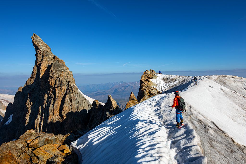
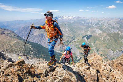
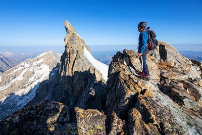
Course type"Peu Difficile" (moderately difficult) – (40/45° on snow, II on rock/mixed), short but high-altitude climb, crevassed glacier, route frequently followed, the rimaye may be open and the first slope accessing the arête may be ice covered.
Embed this item to access it offline
Sunrise at the Refuge de l'Aigle, the imposing glacial ambience, the distant view of Mont Blanc, an arête of perfect snow... all combine to create a sense of harmony with the elements. The approach to La Grande Meije is a life-changing experience, a step towards self-reliance, a high-altitude journey. Everything that makes up mountaineering and the commitment it requires are united in this goal.
2 steps
Description
Leaving Villar-d'Arène, the climb to the Aigle refuge and its rocky crag is made up of steep switchbacks. The climb takes you successively across the Glacier du Bec, the Bec de l'Homme and the Glacier du Tabuchet.
The second stage allows you to climb the Meije Orientale and enjoy its magnificent panorama before take the same route back down to Villar-d'Arène as on the outward journey.
The second stage allows you to climb the Meije Orientale and enjoy its magnificent panorama before take the same route back down to Villar-d'Arène as on the outward journey.
- Departure : Villar-d’Arêne
- Arrival : Villar-d’Arêne
- Towns crossed : Villar-d'Arêne and La Grave
Altimetric profile
Recommandations
In the descriptions, you will find elevations which are intended as a reference point to locate your position on a gradient or slope. These should be taken with a margin of error (~ +/- 30 metres), especially where they are not set or referenced by the IGN. In the last resort, it is your own experience that will guide you when, maybe at the foot of five dihedral corners all indistinguishable from one another, you are complaining bitterly about your guidebook or even a friend's sketch. It would be difficult to grasp all the complexity of a route using just a description or a photo view of the route. Only the three aids together (description/photo with a route overlay/IGN map) will give you a comprehensive picture.
The conditions of a route or the mountain can change, and sometimes the description will differ from what you encounter on the ground. Be your own guide. These descriptions are not absolute reality and sometimes intuition will serve you better than a guidebook. So BONNE ROUTE, with or without a map to lead you through the maze!
From the book by Sébastien Constant (2007), Voies normales et classiques des Ecrins, Éditions Constant, L'Argentière-la-Bessée, p. 18.
Standard equipment for snow and mixed itineraries and glacial terrain: telescopic poles, crampons, ice axe, helmet, harness, 50m climbing rope, belaying and progress equipment, 30-litre bag, warm clothing, safety kit etc.
Is in the midst of the park
The national park is an unrestricted natural area but subjected to regulations which must be known by all visitors.

Information desks

Maison du Parc du Briançonnais
Place Médecin-Général Blanchard, 05100 Briançon
Located at the foot of the medieval town fortified by Vauban, declared World Heritage by UNESCO in 2008, the Maison du Parc Briançon is a welcoming place of information exchange. Three floors of exhibition to discover : the natural and cultural heritage, the museum of the history of skiing in Briançon. Documentation, maps, guidebooks, books and products of the Park. Guided tours for groups by reservation. Free admission.
Tourism Office of La Grave, La Meije - Villar d'Arène
RD 1091, 05320 La Grave
Access and parking
From Villar-d'Arêne, which is accessible via the D1091 from Le Bourg d'Oisans or Briançon, take the minor road D207 towards Pied du Col. At the first junction, turn right for 850m to the Pont Vieux or Les Brebis car park.
Parking :
Pont Vieux or Pont des Brebis car park
More information
Source

Parc national des Ecrinshttps://www.ecrins-parcnational.fr
Report a problem or an error
If you have found an error on this page or if you have noticed any problems during your hike, please report them to us here: