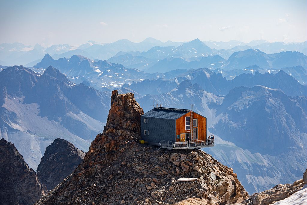
Refuge de l’Aigle at the Rocher de l’Aigle (3,450 m)
Villar-d'Arêne HardDifficulty
Refuge de l’Aigle at the Rocher de l’Aigle (3,450 m)
2j
Duration12,6km
Distance+2251m
Positive Elevation-2250m
Negative ElevationMulti-day trekking
Course typeGrade F+ "Facile +" (easy, upper band) (35° on snow and II on rock), long mixed climb (snow/rock) with some clearly waymarked and very easy rocky sections, Vire Amieux ledge equipped with wire, crevassed glacial terrain.
Embed this item to access it offline
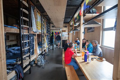
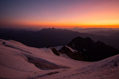
Taking in every alpine zone, from the Romanche mountain river to the Tabuchet glacier, this long ascent is a wonderful discovery of the high-mountain environment. It is not only about the ambience and the landscape but also following in the footsteps of the pioneers of late nineteenth century mountaineering. Clinging to the Rocher de l'Aigle 3,450 m, initially a bivouac site, the refuge that bears its name was built in 1910 and completely rebuilt in 2014.
2 steps
Description
The start of the climb to the Aigle refuge follows a well-marked path as far as the place known as ‘l'Âne’. From there, the path is less obvious. Over rocky slopes and the névés of the Bec glacier, it reaches the col of the same name. The ascent then continues along the north ridge of the Bec de l'Homme before reaching the Tabuchet glacier. The Aigle refuge is not far away.
The descent is by the same route.
The descent is by the same route.
- Departure : Villar-d’Arêne
- Arrival : Villar-d’Arêne
- Towns crossed : Villar-d'Arêne and La Grave
Altimetric profile
Recommandations
The climb to the Aigle refuge is long and the difference in altitude considerable. Start early to give yourself plenty of room and avoid suffering too much from the heat. Up to the Col du Bec, the route follows a well-marked path. Then it's into the realm of the high mountains, where you need to find the route and progress safely (crampons, ropes). After the Amieux cable, access to the glacier can be tricky in late summer when the mountain is dry. If you arrive late at the refuge, it is advisable to sleep there (booking essential). Without climbing one of the summits of the Meije, it is possible to do two short loops on the glacier before descending into the valley: the Tête des Corridors 3734m or the col du Serret du Savon 3571m.
"In the descriptions, you will find elevations which are intended as a reference point to locate your position on a gradient or slope. These should be taken with a margin of error (~ +/- 30 metres), especially where they are not set or referenced by the IGN. In the last resort, it is your own experience that will guide you when, maybe at the foot of five dihedral corners all indistinguishable from one another, you are complaining bitterly about your guidebook or even a friend's sketch. It would be difficult to grasp all the complexity of a route using just a description or a photo view of the route. Only the three aids together (description/photo with a route overlay/IGN map) will give you a comprehensive picture.
The conditions of a route or the mountain can change, and sometimes the description will differ from what you encounter on the ground. Be your own guide. These descriptions are not absolute reality and sometimes intuition will serve you better than a guidebook. So BONNE ROUTE, with or without a map to lead you through the maze!"
From the book by Sébastien Constant (2007), Voies normales et classiques des Ecrins, Éditions Constant, L'Argentière-la-Bessée, p. 18.
Standard equipment for snow and mixed itineraries: telescopic poles, crampons, ice axe, helmet, harness, 30m climbing rope, glacier safety kit, belaying and progress equipment, 30-litre bag, warm clothing.
Is in the midst of the park
The national park is an unrestricted natural area but subjected to regulations which must be known by all visitors.

Information desks

Maison du Parc du Briançonnais
Place Médecin-Général Blanchard, 05100 Briançon
Located at the foot of the medieval town fortified by Vauban, declared World Heritage by UNESCO in 2008, the Maison du Parc Briançon is a welcoming place of information exchange. Three floors of exhibition to discover : the natural and cultural heritage, the museum of the history of skiing in Briançon. Documentation, maps, guidebooks, books and products of the Park. Guided tours for groups by reservation. Free admission.
Tourism Office of La Grave, La Meije - Villar d'Arène
RD 1091, 05320 La Grave
Access and parking
From Villar-d'Arêne, which can be accessed via the D1091 from Le Bourg d'Oisans or Briançon, take the minor D207 road towards Le Pied du Col. At the first intersection turn right and follow this road for 850 metres to the Pont Vieux ou des Brebis car park.
Parking :
Pont Vieux or Pont des Brebis car park
More information
Source

Parc national des Ecrinshttps://www.ecrins-parcnational.fr
Report a problem or an error
If you have found an error on this page or if you have noticed any problems during your hike, please report them to us here: